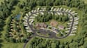
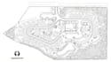
I will create campground maps, rv park layout, land subdivision plans site master plans

J
jorpartan
J
jorpartan
Jordan

About this gig

I will create professional campground maps, RV park layouts, land subdivision plans, and site master plans perfect to your project requirements.


My services include:

  • Campground & RV park master plans
  • RV site layouts & campsite placement
  • Tent, cabin & glamping site layouts
  • Roads, driveways & parking layouts
  • Utility and service area layouts
  • Restroom, office & amenity placement
  • Recreation & common area planning
  • Land subdivision & lot layouts
  • Residential & commercial site plans
  • Property development concepts
  • Site master planning & space planning
  • Property boundary & parcel layouts
  • Access road & circulation planning
  • Parking & vehicle circulation plans
  • Landscape/open-space concepts
  • Amenity and facility placement
  • Existing site redraws & cleanups
  • Sketch/PDF/image to professional site plan
  • 2D vector maps & presentation plans
  • Clean, organized, client-ready drawings


You'll receive a clear, professional and easy-to-understand layout that presents your land, lots, roads, RV sites, amenities and development areas in a practical way.


Send me your survey, sketch, property dimensions, PDF, image or existing plan, and I'll turn your ideas into a polished site layout.

Delivery style preference

Please inform the freelancer of any preferences or concerns regarding the use of AI tools in the completion and/or delivery of your order.

Get to know Jordan

Jordan

Map Pro

  • FromUnited States
  • Member sinceSep 2026
  • Languages

    English
I’m a Mapping Specialist helping clients turn location data, plans, drawings, and geographic information into clear, accurate, and professional maps. I create custom GIS maps, site maps, property and parcel maps, zoning maps, land-use maps, location maps, route maps, and other technical mapping solutions tailored to your project. I can also handle GIS data processing, digitization, georeferencing, CAD-to-GIS conversion, spatial analysis, and map visualization. Send me your data, drawing, coordinates or project requirements and I’ll turn them into a professional map you can confidently use.