Browse categories
English
$
USD
Connect to your AI

Level 2





Hi there,
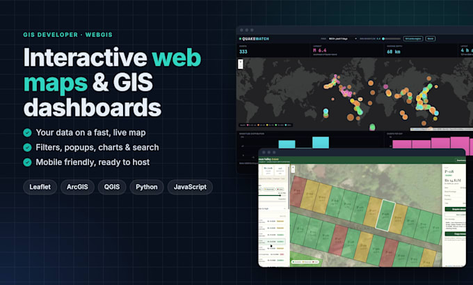
Need your spatial data on a fast, interactive web map? I will build a custom WebGIS map for your website, client or team.
I am a GIS technician with a computer science background. I clean and prepare data in QGIS, ArcGIS and Python, then build the map in Leaflet / JavaScript, so you get a working app, not just a screenshot.
What I can build:
- Interactive maps from Excel, CSV, Shapefile, GeoJSON or KML
- Site plan / plot overlays for real estate
- Dashboards with filters, charts and live data feeds
- Thematic maps (choropleth, heatmap, clusters)
- Store locators and business directory maps
Every map includes:
- Popups, legend and layer control
- Search or filters for your data
- Satellite / street basemap switcher
- Mobile-friendly design
- Full source code, ready to host
How it works: send your data and a short brief, I share a preview within a few days, we refine it, and you get the final files or a hosted link.
Please message me before ordering so I can check your data and confirm the scope. Live demos are in my portfolio.
Best regards,
Paviya :)
Smart, Creative, Reliable
Level 2
Languages
What data formats do you accept?
Excel, CSV, Shapefile, GeoJSON, KML/KMZ, GPX and PDF/image site plans. If your coordinates are messy (mixed formats, swapped lat/long), I clean them first.
Can you add the map to my existing website?
Yes. You get a self-contained map you can embed with an iframe or add to WordPress, Webflow or a custom site. I can also host it for you on GitHub Pages.
Do I need to pay for Google Maps or a map API key?
No. I use free, open basemaps by default (Esri, OpenStreetMap). If you prefer Google Maps or Mapbox, I can use your own API key.
Can the map show live or updating data?
Yes. I can connect public APIs, Google Sheets or GeoJSON feeds so the map updates automatically. Please message me first so I can confirm the source.
What counts as a "data layer"?
One dataset shown on the map, for example a points layer of stores, a polygon layer of districts, or a site plan overlay. The package includes up to 3.
Do I get the source code?
Yes, the full HTML, CSS, JavaScript and processed data files, with a short guide on how to update them.