Browse categories
Explore
Fiverr Pro
English
$
USD
GIS and Drone Mapping Specialist LiDAR, QGIS, Metashape, DEM and Contours
I provide professional automatic LiDAR point cloud classification services using TerraSolid and MicroStation CONNECT.
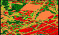
With this gig, I can automatically classify your LiDAR data into standard classes such as ground, vegetation, and buildings. After classification, I can also generate:
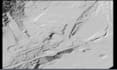
- Digital Elevation Models (DEM)
- Contour lines (custom intervals)
- Volumetric calculations and terrain analysis
This ensures clean, organized, and ready-to-use LiDAR datasets for GIS, CAD, engineering, or environmental projects.
Perfect for clients who need:
- Ground and non-ground point classification
- Vegetation and building classification
- DEMs, contours, and volumetric analysis generated from LiDAR
- Clean, structured LiDAR data ready for mapping, modeling, or reporting
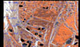
Sample outputs are included to demonstrate the results of automatic classification and derived products. Your data will remain fully secure and processed according to your project requirements.
Can you process my LiDAR data?
Yes! I can classify your LiDAR data and generate DEM, contours, and volumetric outputs tailored to your needs.
Are these sample outputs?
Portfolio examples demonstrate my skills. Real project pricing and delivery time depend on your dataset and requirements.
What formats will you deliver?
AS, LAZ, DEM (GeoTIFF), Contours (DXF / SHP), reports (PDF) or any format requested.


