Browse categories
Explore
Fiverr Pro
English
$
USD
GIS and Drone Mapping Specialist LiDAR, QGIS, Metashape, DEM and Contours
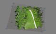
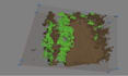
I provide professional drone imagery processing services using Agisoft Metashape to generate accurate terrain models and maps.
With this gig, I can process your drone photos to create:
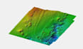
- High-resolution Digital Elevation Models (DEM)
- Contour lines (custom intervals)
- Hillshade and slope analysis
- Orthophoto generation (optional)
This gig is perfect for clients who need:
- Detailed 3D terrain models from drone imagery
- Accurate elevation and contour maps for engineering, construction, or environmental projects
- Volumetric calculations and terrain analysis based on drone data
Sample outputs are included to demonstrate the results of drone imagery processing. Your data will remain fully secure and processed according to your project requirements.
Can you process my drone photos?
Yes! I can generate DEM, contours, slope maps, orthophotos, and volumetric analysis from your drone imagery.
What formats will you deliver?
DEM (GeoTIFF), Contours (SHP / DXF), Orthophotos (JPEG / TIFF), Slope / Hillshade (GeoTIFF), Reports (PDF).
Do you provide sample outputs?
Yes, demo outputs are included to show the quality of my drone imagery processing.


