Browse categories
Explore
Fiverr Pro
English
$
USD


About this Services
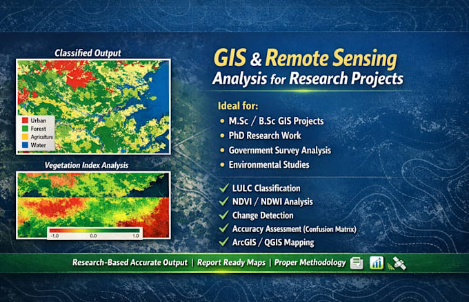
I provide professional GIS and Remote Sensing Services for academic, environmental and government research project. My work is based on scientific methodology, accurate spatial analysis, and high quality map design. Whether you need thematic maps, vegetation analysis or large scale spatial assessment, i deliver reliable and research grade results.
Remote Sensing Services
GIS Services
What I Offer
Satellite Data Source
Sentinel-2, Landsat 8 & 9, MODIS, LISS 3 & 4 (Available in India) and More.
Why Choose Me ?
Research-Based Approach
High Accuracy Results
Clear Visualization & Professional Layout
Experience with Academic & Government Project
100% Clients Satisfaction Focus
Let's bring your geospatial projects to life! Contact me before ordering to discuss your requirements.
ORDER NOW
Founder of Prithvi map
Languages
Will I receive source files?
Yes, source files (ArcGIS/QGIS project files) are included in higher packages or can be provided upon request.
What output formats will I receive?
You can receive maps in PDF, JPEG, PNG, and GIS formats (Shapefile, GeoTIFF, etc.).