I will do gis vegetation analysis and mapping, crop counting, ndvi index

L
l_kobik_uav
L
l_kobik_uav
Liubov

Level 2

About this gig

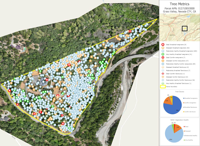
I'm offering vegetation analysis based on orthophoto. For some of the analysis DTM and DSM are additionally required. Both DTM and DSM I can generate from your point cloud if you do not have them


Parameters that can be determined manually/by machine learning/using python script:

  • Crop counting;
  • Vegetation height breakdown;
  • Vegetation coverage area;
  • NDVI, NDWI, NDMI indices (raster maps and csv values);
  • Dead trees;
  • Determination of trees types;
  • Trees counting
  • Comparing before and after

The result will be with vegetation map with statistics, pie chart diagram and legend.

It could be needs for:

  • Road inspection;
  • Power lines inspection;
  • Environmental investigation.

Get to know Liubov

Liubov

GIS and CAD specialist, ecologist

4.9(87)

Level 2

  • FromUnited Arab Emirates
  • Member sinceJun 2022
  • Avg. response time1 hour
  • Last delivery1 month
  • Languages

    English, Russian, Italian, Spanish
I’m GIS specialist/photogrammetrist with ecological background. I have 7 years' experience in GIS field and 5 years' experience in photogrammetry and CAD. Services that I'm offering: - Lidar, drone data processing: • DEM • Ortho • 3D model. - Point cloud processing: • scanning • classification • converting to CAD - 3D modelling: • CAD • photogrammetry. - Digital mapping: • any type of map • geospatial analysis. - Satellite imagery processing: • Vegetation analysis • NDVI • Multispectral analysis. Software: ArcGIS, QGIS, AutoCAD, Civil 3D, Revit, Agisoft Metashape, Global Mapper, Trimble.

My Portfolio