Browse categories
Explore
Fiverr Pro
English
$
USD


Are you losing business value because your spatial data lives in spreadsheets with no geographic context?
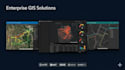
At LineSquare Technologies, we've delivered enterprise GIS solutions to clients like Saudi Aramco across Oil & Gas, Telecom, Agriculture, and Pipeline Integrity Management in 3+ countries.
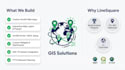
What we build for you:
Our GIS engineers bring 5+ years of hands-on ESRI expertise and 10+ delivered enterprise projects.
Whether you need a simple map viewer or a full pipeline integrity platform, we build to enterprise standards.
Every project deserves a proper scoping conversation before a single line of code is written. Message me to schedule a quick 15-minute discovery call it's the fastest way to ensure we build exactly what your business needs.
Let's talk.
CEO
Languages
What ESRI products and platforms do you work with?
We work with the full ESRI stack: ArcGIS Online (AGOL), ArcGIS Portal, ArcGIS Pro, Experience Builder, Web AppBuilder, ArcGIS Dashboards, and ArcGIS JS API v4.x. We also support QGIS and GeoServer for open-source GIS workflows.
Can you integrate ArcGIS with enterprise systems like SAP?
Yes. We have hands-on experience integrating ArcGIS with SAP, OSIsoft PI, Power BI, Tableau, and custom REST APIs. We've executed this for enterprise clients in Oil & Gas, including Saudi Aramco projects.
Do I need an ArcGIS license before placing an order?
Most solutions require an ArcGIS Online or Portal license from Esri. We'll guide you on the most cost-effective approach during a free discovery call — you don't need to have it sorted before reaching out.
What GIS data formats do you support?
We support Shapefiles (.shp), KML/KMZ, GeoJSON, Feature Services, WMS/WFS, and CSV files with coordinate columns. We can also digitize, convert, and clean your spatial data as part of the engagement.
Which industries have you built GIS solutions for?
We've delivered GIS platforms for Oil & Gas (pipeline integrity), Telecom (FTTH planning), Agriculture, Public Health, and Emergency Response. Our team has delivered multiple projects directly for Saudi Aramco.
Will the web app work on mobile devices?
Yes. All ArcGIS web applications we build are fully responsive and tested across desktop, tablet, and mobile browsers.
What information do you need from me to start?
Your spatial data files, ArcGIS credentials if available, a description of your use case and desired features, and any reference apps. We'll walk through everything in our discovery call.


