Browse categories
Explore
Fiverr Pro
English
$
USD

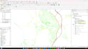
Need more than just a map? I provide advanced GIS and spatial data analysis that helps you make smarter, location-based decisions.
Using industry-standard tools like QGIS and ArcGIS, I transform raw geographic data into clear, actionable insights through high-quality maps and spatial analysis.
This service is ideal for businesses, researchers, real estate professionals, and organizations that rely on geographic data.
My services include:
What you get:
Before placing an order, feel free to message me with your dataset and requirements so I can recommend the best approach.
Ryan Tech
Languages
What type of data do you need to get started?
I can work with: Excel / CSV files (with addresses, coordinates, or location names) GeoJSON, KML, Shapefiles Any dataset with location-related information
Can you convert my addresses into map coordinates?
Yes. I can geocode your addresses and convert them into latitude and longitude for mapping and analysis.
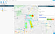
Will I get an interactive map or just an image?
That depends on your package: Basic/Standard → high-quality static maps (PNG/PDF) Premium → optional interactive web-based maps If you need interactivity, please mention it before ordering.
Can you help analyze my data or just visualize it?
I do both. I don’t just create maps—I perform spatial analysis to uncover patterns, trends, and insights from your data.
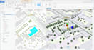
Do you handle large or complex datasets?
Yes. The Premium package is designed for large datasets (thousands of points) and multi-layer analysis.
Do you offer custom projects?
Yes. If your project is unique (e.g., advanced modeling, dashboards, or ongoing work), send me a message and I’ll create a custom offer.
Do you provide source files?
Yes. I can provide source files (e.g., Shapefiles, GeoJSON, project files) depending on your package or request.
Can you deliver urgently?
Yes, I offer fast delivery as an extra. Message me first to confirm availability.
Is my data secure?
Yes. Your data will be kept confidential and will not be shared with anyone.


