I will convert survey points to google maps pin and kml

L
logohost
L
logohost
Khalil Rajput

About this gig

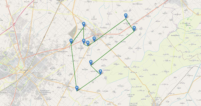
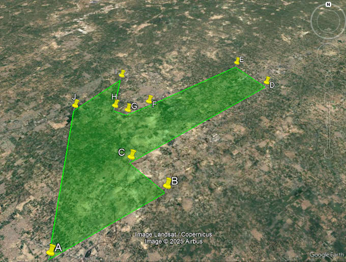
Turn survey points into a clean, shareable map even if you dont know the exact place.


I convert Easting/Northing, UTM, or local grid coordinates into accurate Latitude/Longitude, then deliver a Google Earth KML/KMZ and a beautiful interactive web map (dark/light/satellite) with labeled pins and a crisp boundary just like my gallery images.


What you get


  • Google Earth files: KML & KMZ (open with a double-click)
  • Interactive HTML map: stylish Leaflet map with dark/light/satellite layers, legend, and labeled pins (AJ)
  • Google Maps share link: quick view on mobile/desktop
  • Data files: CSV (lat, lon) + optional GeoJSON / Shapefile
  • Measurements: Area & perimeter report (m², acres, km/mi)
  • Branding & colors: your color scheme, labels, and logo on request


Perfect for


Real estate parcels, mining/lease zones, khasra to map, site plans, farmland, utilities, right-of-way, construction layouts, city planning, reports, and client proposals.

Get to know Khalil Rajput

Khalil Rajput

khalil rajput

5.0(211)
  • FromPakistan
  • Member sinceSep 2017
  • Avg. response time1 hour
  • Last delivery1 month
  • Languages

    Spanish, French, Russian, English
Freelance Illustrator & Graphic Designer | 7 Years of Experience I don't just design — I tell your story visually. Specializing in Logo Design, Brand Identity & Character Design, I've helped businesses and creators transform their ideas into visuals that truly stand out. ✔ 7 Years of Professional Experience ✔ Clean, Modern & Impactful Designs ✔ Unlimited Revisions Until You're Happy ✔ Fast Delivery | All File Formats Included Your brand deserves to be remembered. 💡 💬 Let's connect and create something great!

My Portfolio