Browse categories
Explore
Fiverr Pro
English
$
USD

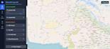
I specialize in creating custom, interactive web-based GIS applications tailored to your specific needs.
WHAT YOU'LL GET:
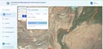
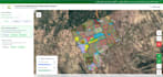
Fully functional web mapping application Interactive map with custom features Responsive design (mobile & desktop) Clean, documented source code Deployment support User-friendly interface ️
TECHNOLOGIES I USE: -
Leaflet.js / Mapbox GL JS / ArcGIS API for JavaScript - OpenLayers / Google Maps API - Backend: Node.js, Python (Django/Flask), PHP - Database: PostgreSQL/PostGIS - Frontend: React, Vue.js, or vanilla JavaScript
FEATURES I CAN IMPLEMENT:
Marker clustering & custom icons Data visualization & heatmaps Search & filtering functionality Distance & area measurements ️ Layer management & toggling Data import/export (GeoJSON, KML, Shapefile) Custom styling & branding Mobile-responsive design
PERFECT FOR: -
Real estate mapping - Delivery/logistics tracking - Environmental monitoring - Asset management systems - Tourism & location-based services - Emergency response systems - Others
CONTACT ME FIRST
to discuss your requirements and get a custom quote! ️ Quick turnaround | Professional quality | Excellent communication
Please be aware that it is against Fiverr's policies for sellers to include themes, templates, or any other elements that infringe third-party rights or applicable laws in the delivered work. Read more about in our Guide to Responsible Digital Creation.
I'm not reclusive at all Just private
Languages


