Browse categories
Explore
Fiverr Pro
English
$
USD

Vetted Pro
Level 2


Malik Fahad was selected by the Fiverr Pro team for their expertise.
GIS & Mapping Data Conversion Services
Accurate - Structured Enterprise - Ready
>< About This Gig
Struggling with incompatible GIS formats, messy CAD drawings, projection errors, or unstructured spatial data?
I provide professional GIS Data Conversion, Digitization, and Spatial Processing Services to transform your data into clean, accurate, and analysis-ready geospatial layers.
With strong expertise in engineering, mining, infrastructure, utilities, and government GIS workflows, I ensure precision, standardization, and delivery excellence.
Services Include:
Why Choose Me?
What You Will Receive
Vetted Pro
GIS Expert, Remote Sensing, Data Analyst, FME, Graphic Design, Excel Analytics,
Level 2
Malik Fahad is part of the Fiverr Pro catalog and has been hand-picked by a dedicated Fiverr Pro team for their skills and expertise.
Vetted for
Data Visualization
Languages
CLARK
Social Insurance
| (1) | ||
| (0) | ||
| (0) | ||
| (0) | ||
| (0) |

phoenixdronepro

United States
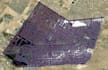
the finished orthomosaic was exactly what the customer needed. thanks
$100-$200
Price
2 days
Duration
| (1) | ||
| (0) | ||
| (0) | ||
| (0) | ||
| (0) |
phoenixdronepro
United States
the finished orthomosaic was exactly what the customer needed. thanks
$100-$200
Price
2 days
Duration


