Browse categories
Explore
Fiverr Pro
English
$
USD

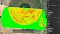
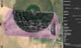
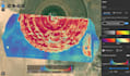
I provide professional multispectral drone services using the DJI Mavic 3M to deliver accurate agricultural and environmental data.
Services include:
Multispectral imaging (RGB + multispectral bands)
NDVI, GNDVI, and vegetation health maps
Field boundary mapping and crop monitoring
Orthomosaic, DSM/DTM, and georeferenced data export
High-accuracy mapping with optional RTK/GCP support
Languages


