Browse categories
Explore
Fiverr Pro
English
$
USD

Level 2
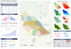
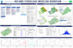
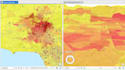

Turn your data into powerful, professional maps and spatial insights!
If you are looking for accurate GIS mapping, advanced spatial analysis, or remote sensing solutions, you are in the right place.
I am a professional GIS and Remote Sensing specialist with expertise in ArcGIS, QGIS, and Google Earth Engine. I help businesses, researchers, and organizations convert raw geographic data into meaningful insights and visually stunning, publication-ready maps.
I offer a wide range of GIS services, including:
My work supports multiple industries such as urban planning, environmental analysis, hydrology, land use mapping, and flood risk assessment. I focus on delivering results that are not only technically accurate but also visually clear and easy to understand.
High
GIS Development, GIS Analysis, Cartography, Web Mapping
Level 2
Languages


