Browse categories
Explore
Fiverr Pro
English
$
USD


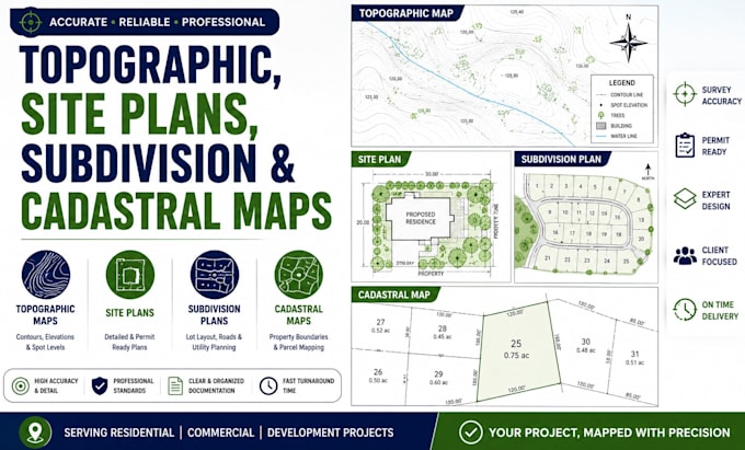
Need professional topographic maps, site plans, subdivision layouts, or cadastral maps for your project? I provide accurate, detailed, and permit-ready mapping solutions for residential, commercial, and land development projects.
My services include:
I create organized and easy-to-understand drawings suitable for architects, engineers, contractors, developers, surveyors, and property owners.
Why choose my service?
I work on residential developments, commercial properties, land planning, road layouts, and subdivision projects while maintaining high drafting and mapping standards.
Lets turn your land and site information into professional and accurate mapping solutions.
Please inform the freelancer of any preferences or concerns regarding the use of AI tools in the completion and/or delivery of your order.
Floor plans, Elevation, Section, Electrical and Site Plan
Languages
What services do you provide?
I provide topographic maps, site plans, subdivision layouts, cadastral maps, parcel mapping, and land development drafting services.
What file formats will I receive?
You will receive professional PDF drawings, CAD files, maps, and project documentation based on your requirements.
Can you create permit-ready site plans?
Yes. I prepare organized and professional site plans suitable for permit and planning purposes.
Do you work with existing survey data or sketches?
Yes. I can work with existing survey files, hand sketches, satellite images, and reference plans.
What types of projects do you handle?
I work on residential, commercial, subdivision, development, and land planning projects.
Can you revise or update existing maps and plans?
Yes. I can modify, update, or redesign existing maps and site plans based on your instructions.