Browse categories
Explore
Fiverr Pro
English
$
USD


Need a clear map for your report, planning project or presentation?
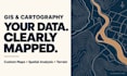
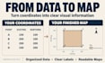
I will turn your spatial data into custom GIS maps and useful analysis using ArcGIS Pro. From study area maps to terrain visualization, I will build outputs around your location, project goals and required formats.
MY SERVICES
WHY CHOOSE ME
Receive PDF or PNG maps, plus the editable data included in your package. Analysis depends on the quality and resolution of your source data. Larger areas, extensive digitizing and satellite analysis need a custom quote.
Send your study area, available files and required output. I will review the scope and recommend the right package with clear deliverables, pricing and timing.
GIS Expert
Languages
What do you need to start my project?
Please provide your study area, available data, project objective, required outputs and deadline. Include the coordinate system and any styling reference if available. I will check these details before confirming the scope.
Which package should I choose?
Basic suits one map from prepared data. Standard adds one agreed analysis operation and two layouts. Premium includes two agreed operations, three layouts and a methods note. Send your files if you need help selecting a package.
Can you help if I do not have GIS data?
I can review whether suitable public data is available and quote for sourcing and preparation. Availability, licensing, date and resolution affect what is possible. Data sourcing is not included in the standard packages.
Which input files can you work with?
Typical inputs include shapefiles, GeoJSON, KML/KMZ, GeoTIFF and CSV or Excel coordinate tables. Please send the complete shapefile set in a ZIP. Scanned maps and CAD files need review before I confirm conversion or georeferencing.
What files will I receive?
Basic includes a PDF or PNG map. Standard includes both exports and the created output layers. Premium also includes an ArcGIS Pro project and a short methods note. We will agree data formats and software compatibility before starting.
Can you create contour and terrain maps?
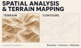
Yes, using suitable elevation data, I can create contours, slope maps or hillshade. Each requested operation must be included in the scope. The results depend on the source elevation data's resolution and accuracy.
Do you offer remote sensing and land-cover mapping?
These need a custom review. Send your area, imagery dates, desired classes or indicators, and intended use. I will confirm the method, feasibility and price before accepting the work.
What does a revision include?
Revisions cover adjustments to agreed outputs, such as labels, colours, legend placement and layout. Additional datasets, study areas, analysis tasks or a changed project objective require an updated quote.
How do you check the results?
I review coordinate systems, layer alignment, relevant attributes, map elements and exports. Where appropriate, I check geometry or topology. I will identify material limitations in the source data; map detail does not guarantee survey-grade accuracy.
Can you deliver urgently?
Please message me with your files and exact deadline before ordering urgent work. I will confirm whether the scope fits my availability and whether an extra fee applies. The listed delivery times apply to the stated package scope.


