Browse categories
English
$
USD
Connect to your AI
FullStack GIS Developer: Custom Web Apps and Spatial Databases
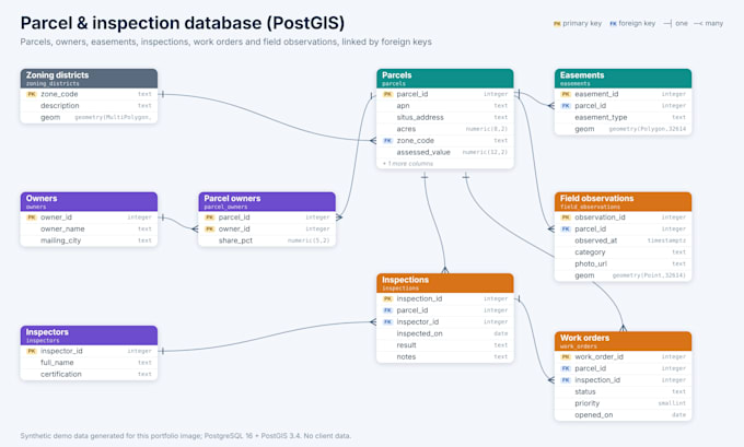
Whether you're migrating off shapefiles, consolidating scattered datasets, or building a production geodatabase from scratch, I design spatial database systems your team can maintain for the long term.
Every project starts with schema design tailored to how your organization collects and uses spatial data. I build topology rules, domains, subtypes, and relationship classes around your actual workflows rather than applying a generic template. When the project involves data migration, I build ETL pipelines that automate recurring imports and validate each record before it reaches production.
I work with PostgreSQL/PostGIS, SQL Server, and Esri enterprise geodatabases. Every build includes connection files so your team can plug in from ArcGIS Pro, QGIS, or a web application on day one. If your tier includes automation, you get scheduled Python scripts with error handling and logging that run without babysitting.
Schema documentation and a maintenance guide come standard across all packages. Describe your current data situation, and I'll recommend the right package.


Database type:
Centralized database
•
Relational database
•
Other
Platform:
PostgreSQL
•
SQLite
•
SQL Server
•
Other
Expertise:
Design
•
ERD
•
SQL
•
Query optimization
Q: What information do you need to get started?
A: I need a description of the datasets you’re working with now (shapefiles, CSVs, spreadsheets, existing databases), how many users will access the database, what GIS software your team uses, and what workflows the database needs to support. If you have an existing schema or ERD, send that too.
Q: Can you work with my existing database or do you only build new ones?
A: Both. I can redesign and migrate an existing database that’s outgrown its current structure, or build a new one from scratch. If you’re migrating, I’ll map your current schema to the new one and build the ETL pipeline to move your data without losing records or breaking relationships.
Q: What’s the difference between PostGIS and an Esri enterprise geodatabase?
A: PostGIS is an open-source spatial extension for PostgreSQL — no licensing fees, works with QGIS and ArcGIS Pro, and handles spatial SQL natively. An Esri enterprise geodatabase runs on PostgreSQL or SQL Server but adds Esri-specific features like topology rules, domains, subtypes, and relationshi
Q: Do I need the ETL tier or just schema design?
A: If your data comes from one source and gets loaded once, the schema design tier covers you. If you receive recurring data from field crews, sensors, partner agencies, or external feeds, the ETL tier automates those imports so your team isn’t manually loading and cleaning data every week.
Q: Will my team be able to manage the database after delivery?
A: Every tier includes schema documentation and a maintenance guide written for your team’s technical level. The automation tiers also include logging so you can see exactly what ran, when, and whether anything failed.