Browse categories
Explore
Fiverr Pro
English
$
USD
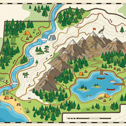

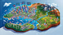

Need a professional, data driven, and visually stunning geospatial map?
I specialize in creating high quality GIS, interactive web, business, travel, election, and educational maps that transform complex geographic data into powerful visual experiences.
My Services:
Why Choose Me?
Whether you need a simple location map or a complex interactive GIS solution, I will deliver a map that is visually appealing, accurate, and tailored to your goals.
Contact me before placing an order to discuss your project requirements and receive the best solution.
Please inform the freelancer of any preferences or concerns regarding the use of AI tools in the completion and/or delivery of your order.
Cartographer and Map Illustration Designer
Languages
Can you work with my existing GIS data, shapefiles, GeoJSON, or spreadsheets?
Yes. I can work with Shapefiles, GeoJSON, KML, CSV, Excel, GPS coordinates, ArcGIS, QGIS, and other geospatial datasets. If your data needs cleaning or preparation, I can handle that too.
What if I don't have any map data yet?
No problem. Many buyers only have an idea or project goal. I can help identify data sources, recommend the best mapping approach, and build a professional map from the available information.
Will my map be suitable for websites, presentations, reports, or printing?
Absolutely. I deliver maps optimized for their intended use, whether for interactive web platforms, business dashboards, presentations, publications, or large-format printing.
How accurate will the geographic information be?
Accuracy is a top priority. All maps are created using professional GIS workflows and verified geographic data to ensure reliable and meaningful results.
Can you create complex custom maps instead of generic templates?
Yes. Every project is tailored to your objectives, audience, branding, and data requirements. You receive a unique, professional map built specifically for your use case.


