Browse categories
Explore
Fiverr Pro
English
$
USD


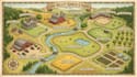
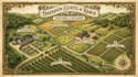
Do you need a clear, professional and visually appealing map for your farm, ranch, orchard or vineyard?
Whether you need a detailed field map for crop planning, a comprehensive ranch map to highlight property boundaries and paddocks or an organized orchard map or vineyard map for visitors and operational management, I am here to help!
I convert satellite images (Google Earth), boundary hand sketches or GPS coordinates into beautifully illustrated and accurate vector maps.
What I Can Include on Your Map:
What You Will Receive:
What I Need to Get Started:
Please contact me before placing an order to discuss your land project specifics!
Please inform the freelancer of any preferences or concerns regarding the use of AI tools in the completion and/or delivery of your order.
Custom Farm Ranch Field And Vineyard Maps
Languages
What do I need to provide to start my map project?
Simply send a satellite link (Google Earth/Maps), property coordinates, or a hand-drawn sketch showing your boundaries and key features. Please include a list of labels, buildings, or roads you want marked on the map.
Can you design maps for large properties, ranches, or multi-field farms?
Yes! I design maps for land of any size from small family orchards and vineyards to multi-acre commercial ranches and agricultural fields. Select a package based on the number of zones/features or message me for a custom quote.
What file formats will I receive with my completed order?
You will receive high-resolution, print-ready files (300 DPI PDF, PNG, JPG). If your package includes source files, you will also receive fully editable vector files (AI, EPS, or SVG).
Can you follow my farm's brand colors and layout style?
Absolutely, Send over your color hex codes, logo, or reference images and I will tailor the map’s color palette, icons, and typography to match your brand style.
What if I need to make changes or update boundary lines later?
Every package includes revisions to fine-tune your design. Furthermore, because I construct all maps as vector graphics, future updates or boundary adjustments can easily be made down the line.


