I will create accurate geodetic plan, topographic survey and site plan drawings

M
mikeecharles
M
mikeecharles
Mike Charles

About this gig

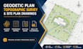
I will create accurate geodetic plan, topographic survey, contour map, and professional site plan drawings in AutoCAD Civil 3D.


Need a reliable expert for your geodetic plan, topographic survey, or site plan drawings? You're in the right place.


I help contractors, architects, developers, and land owners transform survey data into clean, accurate, and professional drawings for construction, planning, and land development projects.


Services I Offer

  • Geodetic plan drafting
  • Topographic survey drawings
  • Site plan creation
  • Contour and elevation mapping
  • Land survey analysis
  • Road alignment drafting
  • AutoCAD Civil 3D drafting


Why Choose This Gig?

  • Accurate and detailed drawings
  • Fast communication and delivery
  • Professional CAD standards
  • Support for small and large projects
  • Clean and organized outputs


Software & Tools

  • AutoCAD Civil 3D
  • AutoCAD
  • GIS Mapping Tools


Whether you need a geodetic plan for approvals or a topographic survey for engineering design, I'm here to help deliver reliable and professional results.


Message me before placing your order so we can discuss your project requirements and choose the best solution for your needs.

Delivery style preference

Please inform the freelancer of any preferences or concerns regarding the use of AI tools in the completion and/or delivery of your order.

Get to know Mike Charles

Mike Charles

Professional Land Surveyor Boundary and Topographic Survey Expert Construction

  • FromUnited States
  • Member sinceMay 2026
  • Avg. response time1 hour
  • Languages

    English
I am a professional Land Survey Specialist with strong expertise in boundary surveys, topographic surveys, construction staking, and survey data analysis. I help contractors, engineers, architects, and landowners make accurate, confident decisions through precise land measurement and clear survey reporting. Using modern surveying methods and data-driven analysis, I deliver high-quality results for site planning, property boundary identification, construction layout, and GIS mapping support. My work is focused on accuracy, reliability, and fast turnaround.