Browse categories
Explore
Fiverr Pro
English
$
USD

Vetted Pro
Top Rated

Naveed was selected by the Fiverr Pro team for their expertise.
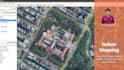
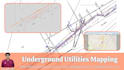
Leverage 21 Years of GIS Mapping Experience for Your Indoor & Outdoor Venues!
I'm Naveed, a GIS specialist with 21 years of experience crafting high-quality digital maps for both indoor and outdoor locations. After honing my skills at a leading French GIS company for 15 years, I've spent the last 6 years growing my own business and freelancing.
My Expertise:
Ready to Discuss Your Needs?
Let's chat about your specific venue mapping project. I'm confident I can deliver exceptional results that meet your requirements.
Vetted Pro
22 Years:GIS Mapping,Data Collection'Cleaning'Visualization
Top Rated
Naveed is part of the Fiverr Pro catalog and has been hand-picked by a dedicated Fiverr Pro team for their skills and expertise.
Vetted for
Architecture & Interior Design
Building Engineering
Building Information Modeling
Data Entry
Data Processing
Data Visualization
Languages
What format you need to start processing the map?
I can use any available format that could be an image file (but should be with better resolution), CAD file, or any raster/vector format which is a valid file.
What format you work as principle and what format you can deliver in?
I work in Shapefile format which is supportive of GIS software like ArcGIS or QGIS. The output could be any raster format i.e. PDF, JPG, TIFF, etc., or any Vector format like SHP, GeoJson, Google Earth KML/KMZ, Microstation DGN, etc.
Which tools you use to produce file?
I use the most common GIS tools like ArcGIS, QGIS, AutoCAD, Global Mapper, Microstation, and Google Earth.
What steps you follow to produce the digital map?
Here is the common process: 1)The file needs to be georeferenced (i.e. to be given proper latitude and longitude) 2)If the file is non-vector, then it needs to be digitized (cartography). 3)Do the file cleaning and checkups 4)Do the attributions to the data 5)Export in the required format


