Browse categories
Explore
Fiverr Pro
English
$
USD

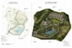

Looking for a professional 2D map, 3D terrain model, elevation map, topographic map, or GIS mapping service? You're in the right place.
I create accurate, high-quality 2D and 3D map designs for architects, civil engineers, surveyors, urban planners, real estate developers, environmental consultants, researchers, and game developers. Whether you need a Digital Elevation Model (DEM), contour map, terrain visualization, or landscape design, I deliver professional results tailored to your project.
My Services
2D Map Design
3D Terrain Modeling
Digital Elevation Model (DEM)
Elevation Map Creation
Topographic & Contour Maps
GIS Mapping (ArcGIS & QGIS)
Site Plan Visualization
Land Development Maps
Landscape Design & Terrain Rendering
LiDAR Data Visualization
CAD to 3D Terrain Conversion
Google Earth & Satellite-Based Terrain Models
SketchUp Terrain Modeling
Civil 3D Surface Modeling
No matter the size of your project, I will create a clean, accurate, and visually impressive map or terrain model that meets your needs.
Please contact me before placing your order so we can discuss your project requirements and recommend the best package for you.
Fiverr does not screen freelancers in this category. Please verify qualifications and discuss requirements with the freelancer before ordering, including any preferences regarding the use of AI tools.
3D model 3d cad 3d minature
Languages
What file formats do you provide?
I can deliver PNG, JPG, PDF, DWG, DXF, OBJ, STL, FBX, SKP, and other formats upon request.
Can you create maps from Google Earth, survey data, or GIS files?
Yes. I can work with Google Earth imagery, survey drawings, CAD files, shapefiles, DEMs, LiDAR data, and other GIS datasets.
Do you create realistic 3D terrain models?
Yes. I create detailed 3D terrain models suitable for architecture, engineering, planning, presentations, simulations, and visualization
Can you customize the design based on my project?
Absolutely. Every map and terrain model is tailored to your specific requirements, including style, scale, and output format.


