Browse categories
Explore
Fiverr Pro
English
$
USD

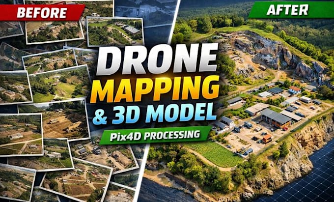
Have drone images ready but don't know how to turn them into accurate maps and 3D models?
Whether you're working on a construction project, land survey, agriculture, mining, or infrastructure development, I can transform your aerial imagery into professional geospatial deliverables using Pix4D.
I specialize in processing drone imagery into orthomosaic maps, 3D maps, Digital Terrain Models (DTM), Digital Surface Models (DSM), point clouds, contour maps and volume calculations with precision and attention to detail. Every project is processed using industry standard workflows to deliver reliable results for GIS, CAD, BIM and engineering applications.
What You'll Receive:
Whether you're a surveyor, engineer, architect, contractor, researcher or drone operator, I'm committed to delivering accurate, professional results that help you make confident decisions.
Send me your drone images and project details before placing an order, and I'll recommend the best workflow for your project.
Please inform the freelancer of any preferences or concerns regarding the use of AI tools in the completion and/or delivery of your order.
3d cad modelling specialist
Languages
1. What files do I need to provide?
Upload your drone images in JPG, JPEG, PNG, or RAW format. If available, include GPS/geotag information for the best accuracy.
2. Which software do you use?
I use Pix4D to process aerial imagery into accurate mapping and 3D reconstruction deliverables.
3. What deliverables can I receive?
Depending on your package, you can receive: Orthomosaic Maps 3D Models DTM DSM Point Clouds Contour Maps Volume Calculations
4. Can you process large drone datasets?
Yes. If your project contains more than 500 images, please contact me for a custom offer.
5. Do I need to contact you before ordering?
Yes. Please message me first so I can review your project, image quality, and requirements before you place an order.