Browse categories
Explore
Fiverr Pro
English
$
USD


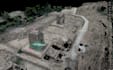
Are you looking for accurate drone data processing for surveying, construction, mining, agriculture, or land development?
I provide high-precision UAV photogrammetry processing using industry-standard software to transform your raw drone images into actionable geospatial outputs.
What I Can Deliver:
Softwares i use:
Please contact me before placing an order!
Fiverr does not screen freelancers in this category. Please verify qualifications and discuss requirements with the freelancer before ordering, including any preferences regarding the use of AI tools.
Highway and Road Geometric Designer
Languages
What files do you need?
Raw drone images (JPG/TIFF), GCP data (if available), coordinate system info.
Do you handle large datasets?
Yes, contact me before ordering for custom offers.


