I will analyze remote sensing , gis, geoai and environmental maps professionally

N
niazali24
N
niazali24
Niaz Ali

About this gig

Contact for Pricing


My Services Include:

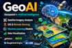
Climate Data Analysis (Temperature, Rainfall, Urban Heat Island, Drought)

Remote Sensing for Environmental Monitoring (NDVI, LULC, Change Detection)

High-Resolution GIS Mapping & Visualization (GeoAi)

Custom Google Earth Engine (GEE) Scripts for Climate Studies

Professional Reports & Presentations

Accurate Geospatial Insights

100% Client Satisfaction

Get to know Niaz Ali

Niaz Ali

:::::::::(RS and GIS):::::::::: Sense : Analyze : Act

5.0(1)
  • FromPakistan
  • Member sinceNov 2021
  • Avg. response time1 hour
  • Last delivery1 year
  • Languages

    Urdu, Pashto, English
I am a Remote Sensing & GIS expert specializing in Google Earth Engine (GEE), ArcGIS, and QGIS. I collaborate with a professional architect to deliver complete geospatial and design solutions. My Services Include: GIS & Remote Sensing: ✅ GIS Mapping & Cartography ✅ LULC, NDVI/EVI Analysis ✅ Satellite Image Processing ✅ GEE & Climate Data Architecture (collaboration): ✅ 2D Plans & 3D Modeling ✅ Interior & Exterior Design ✔ Accurate, high-quality results ✔ Fast delivery & clear communication Message me to get started!

My Portfolio