Browse categories
Explore
Fiverr Pro
English
$
USD


I will create high-quality and professional GIS maps using QGIS. I can design clean, accurate, and visually appealing maps for reports, research, planning, and presentations.
What I can create:
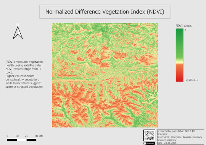
Choropleth maps Heatmaps (density analysis) Land Cover maps (WorldCover / ESA) NDVI & satellite-based vegetation maps DEM, hillshade, and terrain visualization Point cluster maps and thematic maps
What you receive:
A polished and clear map layout PNG or PDF export Professional symbology, legend, scale bar, and projection info
Why work with me: GIS & Remote Sensing specialist Fast delivery and excellent communication Accurate data sources (OSM, ESA, Copernicus, Sentinel-2) Clean and modern cartographic design.
What I need from you:
Your data (CSV, SHP, coordinates, or description) The map type you want Any style preferences Feel free to contact me before ordering!
Please inform the freelancer of any preferences or concerns regarding the use of AI tools in the completion and/or delivery of your order.
GIS,RS Specialist , Custom Maps Spatial Analysis
Languages
What data do you need from me to start?
I can work with any format: CSV, Excel, SHP, GeoJSON, KML, coordinates, or even a description. If you don’t have data, I can help you find reliable sources.
Can you match a specific map style or color palette?
Yes. I can follow your preferred colors, branding guidelines, or replicate any reference map you provide.
Do you provide source files?
Yes. QGIS project files (.qgz) or layer styles can be delivered if you select the source file option.
What if I’m not sure which map type I need?
Just tell me your goal (report, research, visualization, planning), and I’ll recommend the most suitable map type.
Will the map be high‑resolution and ready for printing?
Absolutely. All maps are delivered in high‑quality PNG/PDF formats, suitable for printing or presentation.