Browse categories
Explore
Fiverr Pro
English
$
USD


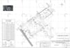
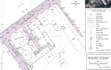


I will create accurate topographic maps, contour plans, and terrain surface models using Autodesk Civil 3D.
My services include:
Topographic drafting from survey data
Surface creation and contour generation
Civil 3D terrain modeling
Layout sheets and plan production
Existing ground and proposed surface plans
Survey point processing
Earthwork and grading support drawings
I can work with:
DWG
LandXML
CSV point files
PDF drawings
Total station/GNSS survey data
Why work with me?
Professional Civil 3D workflow
Accurate and clean drafting
Fast communication
Construction-ready deliverables
High-quality CAD standards
Please contact me before placing large or complex orders.
Please inform the freelancer of any preferences or concerns regarding the use of AI tools in the completion and/or delivery of your order.
Civil 3D Engineer Site Grading, Drainage and Road Design
Languages
What files do you need to start the project?
Please provide survey data, CAD files, point files, PDFs, sketches, or any available topographic information.
Which software do you use?
I mainly use Autodesk Civil 3D and AutoCAD for topographic drafting and surface modeling.
Can you create contour maps from survey points?
Yes. I can generate accurate contours and terrain surfaces from CSV, TXT, LandXML, or survey point data.
Do you provide source files?
Yes. Source DWG/Civil 3D files are included in Standard and Premium packages.
Can you handle large or complex terrain projects?
Yes. I can work on large-scale infrastructure, land development, and complex terrain modeling projects.


