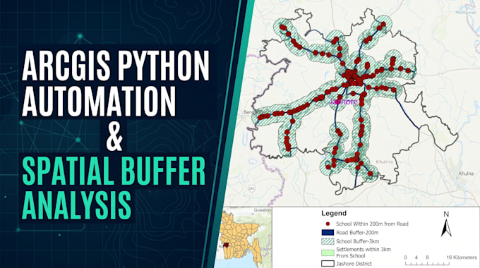
I will automate arcgis workflows with python arcpy and perform spatial buffer analysis

O
ossain04
O
ossain04
Sakawat Hossain

About this gig

Need custom Python scripts (ArcPy) to automate GIS workflows or perform spatial proximity and buffer analysis?


I automate repetitive geoprocessing tasks and create publication-ready maps in ArcGIS Pro, ArcMap, and QGIS.


What I Offer:


  • ArcGIS Python (ArcPy) Scripting: Automated clipping, buffering, intersecting, spatial joins, and batch vector processing.

  • Proximity & Buffer Analysis: Road network buffers, facility service-area zones, and accessibility mapping.

  • Cartographic Map Layouts: High-resolution maps with inset locator maps, legends, scale bars, and north arrows.

Deliverables:


  • Clean, commented Python script (.py)

  • High-resolution maps (300 DPI PDF/PNG)

  • Processed shapefiles / geodatabase (.shp, .gdb)

Message me with your study area, shapefiles, and analysis rules before placing an order!


Get to know Sakawat Hossain

Sakawat Hossain

GIS an Data Visualization Expert

  • FromBangladesh
  • Member sinceApr 2021
  • Languages

    Bengali, English
Hi, I’m Sakawat Hossain, a GIS & Remote Sensing Specialist turning spatial data and satellite imagery into publication-ready maps and insights using ArcGIS Pro, ArcMap, QGIS, and Python (ArcPy). Services: • Satellite Analysis (NDVI, NDWI, NDBI, LULC) • Multi-Year Change Detection • Buffer, Proximity & Network Analysis • Python (ArcPy) Geoprocessing Scripts • Digitizing & Georeferencing • DEM, Terrain & Watershed Analysis • Site Suitability (MCDA) • Custom Cartographic Layouts Accurate results, clean source files, and fast delivery. Message me to discuss your project!