Browse categories
Explore
Fiverr Pro
English
$
USD


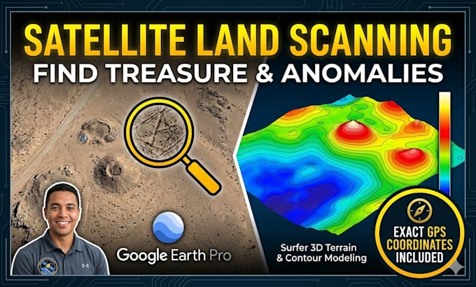
Turn Satellite Data into a Roadmap for Discovery
Are you searching for hidden history, lost structures, or geological anomalies? Stop searching blindly. Use professional Remote Sensing and 3D Terrain Modeling to see what is hidden beneath the surface.
I analyze land topography and identify man-made or geological "hotspots." Whether you are a treasure hunter, amateur archeologist.
What I Provide:
The Deliverables:
"I combine satellite imagery with advanced topographic math to show you what the naked eye misses."
[DISCLAIMER]: This service is for research and identification of anomalies. I do not guarantee the presence of physical treasure. Please ensure you have legal permission to access any identified sites.
Turning Satellite Data into Precision Discovery
Languages
Can you see gold or buried treasure underground?
Satellite sensors cannot "see" metal through the earth. Instead, I use Remote Sensing and 3D Topography to identify man-made anomalies—such as buried foundations, old roadbeds, or non-natural mounds. These are the high-probability spots where treasures and historical artifacts are most likel
What do I need to provide for the scan?
I simply need the GPS coordinates (Latitude and Longitude)
Does this work in heavily forested areas?
In areas with thick tree cover, standard satellite imagery is limited. However, I use historical imagery (to find views from different seasons when leaves are gone) and 3D modeling to detect large-scale ground variations that might suggest hidden structures beneath the canopy.
How accurate are the GPS coordinates you provide?
The coordinates I provide are as accurate as the satellite data used (usually within 1-3 meters). These are intended to get you to the immediate vicinity of the anomaly so you can begin your physical search or metal detecting.
Is my location data kept private?
Absolutely. I treat all client locations and research findings with 100% confidentiality. Your coordinates and the results of your scan will never be shared with third parties or used for any other purpose.