Browse categories
Explore
Fiverr Pro
English
$
USD
Master's Degree in Computer Science Engineering
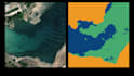
How many times have you needed a dataset already labeled and provided with multiclass masks to use to perform training or test of Machine Learning models for semantic segmentation of satellite images? Although several free datasets are available online for this purpose, only some of them present labeled masks suitable for the purpose mentioned above.
Trying to solve this problem I offer the following service, namely: i will do automated labeling of satellite images for semantic segmentation. Starting from the provided satellite images, with the help of Machine Learning I will create the related multiclass masks automated annotated with 90% approximately accuracy rate.
P.N. --> The size of the provided images is not relevant, however they must be true color RGB images with exactly 3 classes to identify.


Technique:
Automated
Tagging type:
Image


