Browse categories
Explore
Fiverr Pro
English
$
USD


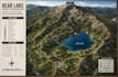
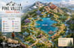
Need a professional hiking, trail, park, recreation, campground, or outdoor adventure map?
I create high-quality custom maps designed for parks, hiking trails, nature reserves, campgrounds, tourism organizations, recreation departments, outdoor brands, and guidebooks.
Using professional cartographic design techniques and GIS mapping tools, I deliver clear, attractive, and easy-to-read maps that help visitors navigate trails, facilities, landmarks, viewpoints, parking areas, campgrounds, and recreational spaces.
What I can create:
Why choose me?
Files can be delivered in PDF, PNG, JPG, SVG, AI, EPS, and other requested formats.
Contact me before ordering if your project includes large parks, extensive trail systems, or multiple map pages.
Please inform the freelancer of any preferences or concerns regarding the use of AI tools in the completion and/or delivery of your order.
Professional Cartographer And GIS Map Designer
Languages
What information do you need to start?
I need trail data, park boundaries, GPS tracks, reference maps, branding guidelines, or a description of the area you want mapped.
Can you use GIS or GPS data?
Yes. I can work with GIS files, GPS tracks, shapefiles, KML, GeoJSON, and other mapping data formats.
Will the map be suitable for printing?
Absolutely. All maps can be delivered in high-resolution print-ready formats.
Can you add my logo and branding?
Yes. Standard and Premium packages include branding customization.
Do you provide editable source files?
Yes. Premium package includes editable source files.
Can you create maps for campgrounds and nature parks?
Yes. I design maps for campgrounds, national parks, recreation areas, nature reserves, and tourism destinations.
What file formats do you deliver?
PDF, PNG, JPG, SVG, AI, EPS, and other formats upon request.
Do you offer large multi-trail network maps?
Yes. Large projects are best suited for the Premium package or a custom offer.


