Browse categories
Explore
Fiverr Pro
English
$
USD


Hello,
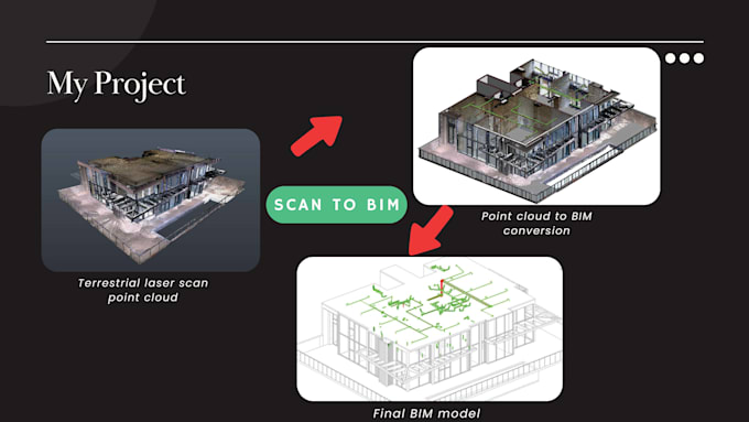
I provide professional Scan to CAD & Scan to BIM modeling services based on point cloud data from terrestrial laser scanning or UAV LiDAR surveys.
Using your registered point cloud files (RCP, E57, LAS, LAZ, etc.), I convert accurate as-built conditions into clean, well-structured CAD drawings and 3D models suitable for engineering, architectural, and construction workflows. My focus is on geometric accuracy, correct alignment, and clear model organization, ensuring reliable results for design, coordination, and documentation.
This gig covers modeling only. Point cloud registration and color or textured models are not included unless discussed in advance.
Deliverables may include:
Output formats:
Ideal for scan-to-CAD documentation, scan-to-BIM projects, as-built drawings, and renovation or retrofit works.
If you have large datasets or specific modeling standards, feel free to contact me before ordering.
Fiverr does not screen freelancers in this category. Please verify qualifications and discuss requirements with the freelancer before ordering, including any preferences regarding the use of AI tools.
Geomatics Expert
Languages
1. What point cloud formats do you accept?
I accept most common point cloud formats, including RCP, E57, LAS, LAZ, PTS, and PTX. Please make sure the point cloud is already registered and aligned before delivery.
2. What level of detail (LOD) do you provide?
The default output is geometry-only modeling without materials, colors, or textures. LOD can be adjusted based on your project requirements—please contact me before ordering for custom needs.
3. What files will I receive?
Standard deliverables include DWG and PDF. RVT or IFC files can be provided upon request, depending on the selected package.
4. Can you handle large or complex point cloud datasets?
Yes. I have experience working with large-scale and high-density point cloud data for architectural, industrial, and infrastructure projects. Feel free to message me to discuss dataset size and scope.
6. How accurate is the CAD/BIM model compared to the point cloud?
The model is created directly from the provided point cloud and follows its geometry as closely as possible. Typical accuracy depends on the quality and density of the input data, and can be discussed in advance if specific tolerances are required.