Browse categories
Explore
Fiverr Pro
English
$
USD


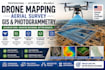
I provide professional drone mapping, aerial surveying, photogrammetry, and GIS analysis services for clients across Texas, California, and the United States. My goal is to deliver highly accurate geospatial data for construction, real estate, land development, agriculture, and engineering projects.
Using advanced photogrammetry workflows, I convert drone imagery into precise deliverables such as orthomosaic maps, 3D terrain models, digital elevation models (DEM), contour maps, and CAD-ready outputs. Every project is processed with attention to accuracy, scale, and industry standards suitable for engineering and planning decisions.
My services help you reduce surveying costs and time while improving data accuracy for site analysis, land measurement, and project planning. Whether you need construction site mapping, land survey reports, or GIS spatial analysis, I provide clean and professional outputs ready for technical use.
What you can expect:
I work with clients in real estate development, construction companie
Please inform the freelancer of any preferences or concerns regarding the use of AI tools in the completion and/or delivery of your order.
AEROSPACE ENGINEER, MECHANICAL 3D, CAD, SOLIDWORKS
Languages
1: What do you need to start the project?
I need your drone images, project location details, and required output format (GIS, CAD, or map type).
2: What deliverables will I receive?
You will receive orthomosaic maps, 3D models, GIS layers, contour maps, and CAD-ready files depending on your package.
3: Do you follow US standards for mapping and measurements?
Yes, all outputs are aligned with standard US engineering and surveying practices used in Texas and California projects.
