Browse categories
Explore
Fiverr Pro
English
$
USD

1 order in queue

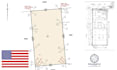
Are you looking for a professional specialist to convert your land survey sketches, topo maps, scanned plats, PDFs, or handwritten field notes into clean and accurate AutoCAD drawings?
You are in the right place.
I provide professional land survey CAD drafting services for surveyors, civil engineers, architects, contractors, developers, and homeowners who need precise, editable, and permit-ready CAD files.
I will transform your rough sketches, PDFs, survey images, or topo maps into organized engineering-grade drawings with proper layering, dimensions, annotations, and plotting standards.
My Services Include:
What You Will Receive:
Lets transform your survey into a professional CAD drawing ready for permitting, design, and construction.
Please inform the freelancer of any preferences or concerns regarding the use of AI tools in the completion and/or delivery of your order.
Survey CAD Conversion Expert
Languages
