Browse categories
Explore
Fiverr Pro
English
$
USD


_vrwffz.jpg)
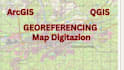
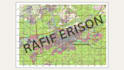
Got an old map, blueprint, or scanned image that you want to turn into real GIS data? I've got you covered. I'll help you georeference your scanned map so it lines up perfectly with real-world coordinates, then digitize the features you need like roads, boundaries, rivers, or anything else, and export them into usable formats like SHP or GeoJSON.
This gig is perfect if you're working on:
What I can deliver:
Georeferenced raster (GeoTIFF or image + world file)
Digitized vector layers (SHP, GeoJSON, KML, DXF)
Custom symbology if needed
Clean and organized attribute tables
Layout map in PNG or PDF (Premium only)
Packages:
Got questions or a custom request? Just drop me a message, I'd be happy to chat before you order.
Let's turn your scanned maps into smart GIS data
Precision GIS Solutions for Your Spatial Needs
Languages
What kind of files can you georeference?
I can georeference scanned maps in JPG, PNG, PDF, or TIFF format. If you have something else, feel free to ask — I’ll check if it works
What coordinate system do you use?
I can use any coordinate system you prefer — WGS84, UTM, local projections, etc. Just let me know what you need. If you’re unsure, I can suggest one based on your location.
Can you digitize features like roads, rivers, or buildings?
Absolutely! Just let me know what features you want extracted, and I’ll turn them into clean, editable vector layers (SHP, GeoJSON, etc.).
Will the digitized data be ready for use in QGIS or ArcGIS
Yes! All files I deliver are compatible with major GIS software like QGIS, ArcGIS, and even online tools like Mapbox or Leaflet.
Can you handle large or high-resolution maps?
Yep! I’m used to working with large maps and high-res scans. If the file is too big for Fiverr upload, we can use Google Drive or WeTransfer.
I have multiple maps or a custom request — can you help?
Definitely. Just send me a message with the details and I’ll get back to you with a custom offer that fits your needs.


