Browse categories
Explore
Fiverr Pro
English
$
USD


_yhialz.jpg)
Hi and welcome to my Gig!
If you need a professional flood susceptibility or flood
risk zone mapping expert using ArcGIS Pro, you are in
the right place.
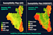
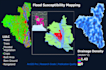
I am a GIS specialist with real research experience in
flood susceptibility mapping I have contributed to
published academic research on flood analysis for
flood-prone regions of Bangladesh.
My Services
Why Choose Me?
Message me before ordering let's discuss your
study area, data, and project needs together!
GIS specialist making publication quality maps for research
Languages
What information do I need to provide before you start?
Please share your study area name or boundary shapefile, the purpose of the project (research, thesis, planning), and any specific data you already have such as DEM, rainfall, or soil data. If you have no data, I can source publicly available datasets for your area.
Can you work on any country or region?
Yes. I can work on any study area worldwide as long as publicly available data exists for that region, such as SRTM DEM, Landsat, Sentinel-2, and other open-source datasets. Just share your area details and I will confirm data availability before you order.Please see my profile portfolio.
What software do you use for the analysis?
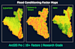
I use ArcGIS Pro exclusively for all GIS processing, spatial analysis, hydrological modeling, and cartographic map design. All outputs are produced and quality-checked within ArcGIS Pro.Also use GEE for collect data if need and also Machine Learning for better Accuracy.
Is this suitable for academic research or journal publication?
Yes. My Premium package is specifically designed for publication-quality outputs. I have personal experience contributing to peer-reviewed research on flood susceptibility mapping, so I understand the standards required for academic and journal submissions.
What if I am not satisfied with the delivered maps?
I offer revisions with every package (1 for Basic, 2 for Standard, 3 for Premium). If there is any issue with the output, please message me and I will resolve it within the revision limit. My goal is 100% client satisfaction.


