Browse categories
Explore
Fiverr Pro
English
$
USD
Bolivia
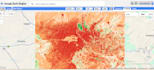
Are you looking for professional satellite data processing without the hassle of downloading terabytes of data? I am a Remote Sensing Specialist and I will use Google Earth Engine (GEE) to provide high-level geospatial insights.
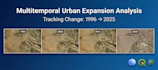
From monitoring agricultural health to tracking urban expansion over decades, I deliver scientific results backed by data.
What I can do for you:
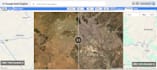
Why GEE? Google Earth Engine allows for petabyte-scale analysis in seconds. I combine this power with QGIS for professional cartographic layouts and Python for advanced data visualization.
I have extensive experience working with the La Paz Metropolitan Area (Bolivia) and other complex terrains. I guarantee precision and scientific rigor.
Please contact me before ordering to discuss your specific project goals!
Technology:
arcgis
•
Other
Expertise:
Time series analysis
•
Thematic analysis
Programming language:
Python
•
R
•
SQL
•
Java


