Browse categories
Explore
Fiverr Pro
English
$
USD
Bolivia
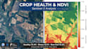
Stop guessing the health of your crops. Start measuring with Satellite Intelligence.
As a Geographic Engineer specialized in Google Earth Engine (GEE) and Statistical Modeling (R), I don't just send you colorful maps; I provide actionable data to optimize your harvest and reduce fertilizer costs.
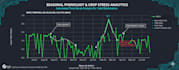
I process Sentinel-2 (10m resolution) imagery to monitor vegetation health, detect water stress, and predict yield potential anywhere in the world.
What you will get:
Why choose this Gig?
Perfect for: Agronomists, Farm Managers, and Environmental Consultants.
Please contact me before ordering to confirm your Area of Interest (AOI).
Technology:
Google Data Studio
•
RStudio
Expertise:
Prediction
•
Probability
•
Statistics
•
Time series analysis
Programming language:
R
•
SQL
What do I need to provide?
I just need the boundary of your farm. You can send a Shapefile (.shp), KML/KMZ, or even a set of GPS coordinates.
Can you work with cloudy days?
Optical satellites (Sentinel-2) cannot see through thick clouds. However, my Premium package includes "Cloud Masking" techniques or Sentinel-1 (Radar) data integration to minimize data gaps.


