Browse categories
Explore
Fiverr Pro
English
$
USD

_zm6b4v.jpg)
Unlock the Power of Location Intelligence with Data-Driven GIS Solutions
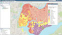
Do you need more than just a basic map? I specialize in turning complex spatial data into clear, strategic insights for your business and research needs.
As an Urban & Regional Planning (BURP) scholar and an APA (American Planning Association) Student Member, I bring academic rigor combined with advanced technical skills in Python, Machine Learning, and GIS. Unlike standard map designers, I approach every project as a data scientist. Whether you are working on an urban research paper, real estate site selection, or a business expansion plan, I help you visualize the "where" and understand the "why."
My Specialized Services:
AI ML Expert, Geospatial Data Scientist, Automation
Languages
What software do you use for mapping?
I primarily use ArcGIS and QGIS. For advanced data processing and automation, I use Python (GeoPandas, Folium).
Can you help with Urban Planning research projects?
Yes! As an Urban Planning student with research experience, I can assist with suitability analysis, zoning maps, and data interpretation.
Do you provide the source code/files?
Yes, the source files (Shapefiles, .ipynb, .mxd) are included in the Standard and Premium packages.


