Browse categories
Explore
Fiverr Pro
English
$
USD



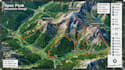
I specialize in creating custom, visually engaging maps for parks, trails, hiking routes, and outdoor adventure locations. Whether you need a detailed trail map for hikers, a travel map for tourists, or an illustrated map for your park or adventure business, I can deliver clear, professional, and accurate designs.
My services include:
Why Choose Me
I work with both simple and complex projects, adapting the map style and level of detail to match your needs.
Before Ordering:
Please provide any available reference materials such as GPS data, sketches, Google Maps screenshots, trail information, logos, branding guidelines, or points of interest you would like included.
Please inform the freelancer of any preferences or concerns regarding the use of AI tools in the completion and/or delivery of your order.
map designer
Languages
Can you create an illustrated map from my reference materials?
Yes. I can work from Google Maps, GPS data, sketches, satellite images, photos, or other references to create a custom illustrated map.
Can you customize the map to match my preferred style?
Absolutely. I can create a clean, detailed, illustrated, or adventure-style map based on your requirements and reference examples.
Can you include trails, landmarks, routes, and points of interest?
Yes. I can include trails, roads, landmarks, viewpoints, facilities, routes, labels, and other important locations you need on the map.


