Browse categories
Explore
Fiverr Pro
English
$
USD

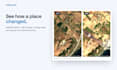

Hi, we're a GIS team that works with satellite data every day.
Want to see how a place has changed? A construction site, a coastline, a forest, farmland or a growing city. We use free, official satellite archives to show what changed, where and when.
What we can do for you:
- Before and after images of your area for any years since 2017
- Yearly image series to follow a project step by step
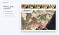
- Change maps that highlight new roads, buildings or cleared land
- Vegetation health analysis (NDVI) over time
- Area statistics: how many hectares changed
- Older years back to the 1980s with Landsat (as an extra)
Good to know:
- We use Sentinel-2 (10 m) and Landsat (30 m) imagery. This is ideal for areas, fields, sites and districts. It does not show cars or single small buildings.
- Need sharper, very high-resolution images? Ask us first and we'll explain the commercial options.
Send us the location and the years you're interested in. We'll check image availability before you order.
Senior GIS, ArcGIS Developer, Web GIS, Esri Enterprise, PostGIS
Languages
How detailed are the images?
Sentinel-2 has 10 m pixels, Landsat 30 m. Roads, fields, construction sites and districts are clear; cars and small houses are not.
Which years are available?
Sentinel-2 from 2017 to today, Landsat back to the 1980s. Cloudy seasons can limit some dates; we check before you order.
Can I use the results commercially?
Yes. Sentinel-2 and Landsat data are free to use, including commercially. A short data credit line is included.
Do I need any software?
No. You get images and a PDF you can open anywhere. GIS-ready files are available as a custom offer.
Can you analyze a very large area?
Yes, from a single site to a whole district. Very large regions may need a custom offer.


