Browse categories
Explore
Fiverr Pro
English
$
USD
Expert Reality Capture and Digital Twin Specialist
Looking for a GIS expert on your next project?
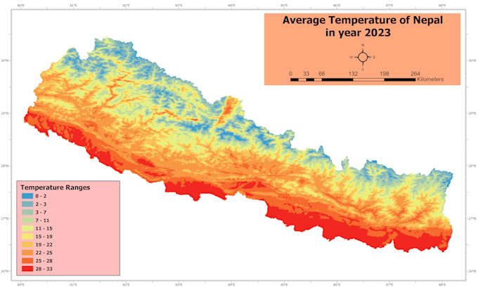
As a Geomatics Engineer, I provide professional-grade GIS services and remote sensing analysis using ArcGIS Pro, QGIS, and ENVI. Whether you need complex spatial modeling or satellite imagery refinement, I deliver reliable data-driven insights.
Core Expertise:
Why Hire a Geomatics Engineer?
I don't just run tools; I ensure the underlying coordinate systems and algorithms are correct. Expect high-quality, dedicated service tailored to your project's specific requirements.
Ready to start? Send a message to discuss your project workflow.


| (1) | ||
| (0) | ||
| (0) | ||
| (0) | ||
| (0) |
artwithleo

New Zealand
Great to work with Rupesh, fast communication and professional work.
Up to $50
Price
2 days
Duration
| (1) | ||
| (0) | ||
| (0) | ||
| (0) | ||
| (0) |
artwithleo
New Zealand
Great to work with Rupesh, fast communication and professional work.
Up to $50
Price
2 days
Duration