Browse categories
Explore
Fiverr Pro
English
$
USD


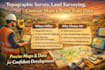
Professional Topographic Survey, Land Surveying, Contour Maps & Point Topo Data
Do you need accurate topographic maps, contour data, and land survey information for construction, engineering, drainage, or site planning? I provide professional land surveying and topographic mapping services that deliver precise elevation, boundary, and terrain data you can trust for successful project execution.
Using modern surveying methods and GIS-ready workflows, I create detailed contour maps, point topo datasets, and land survey drawings that help architects, civil engineers, and developers design with confidence and avoid costly errors.
What I Offer
Why Choose Me
I focus on accuracy, clarity, and compliance. Every map and dataset is carefully verified to meet engineering, planning, and permit requirements, ensuring your designs are based on reliable field-grade data. Fast delivery, clear communication, and professional results are guaranteed.
Lets turn your land into precise, actionable topo data for smarter planning and smooth approvals.
Fiverr does not screen freelancers in this category. Please verify qualifications and discuss requirements with the freelancer before ordering, including any preferences regarding the use of AI tools.
Land Survey Engineering
Languages
