Browse categories
Explore
Fiverr Pro
English
$
USD

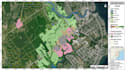
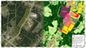
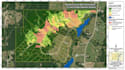
Need satellite imagery turned into maps and numbers you can use? I analyze Sentinel 2 and Landsat imagery for your area and deliver NDVI maps, remote sensing classification (LULC) and land change detection with hectare level statistics.
WHAT YOU GET
WHAT I NEED
Your area of interest (KML, GeoJSON, shapefile or place name), the dates or years, and what the results are for.
GOOD TO KNOW
Optical imagery is cloud limited, so an exact date may not exist; I we suggest the nearest clean scene. I use free public imagery unless you supply your own. At 10 m (Sentinel 2) or 30 m (Landsat), single trees cannot be resolved. Not included: field surveys, official certification, drone data. Huge areas need a custom offer.
Message me your area and goal before ordering and I'll recommend the right package.
map design
Languages
Which satellite imagery do you use?
Free public Sentinel-2 (10 m) and Landsat (30 m) imagery, chosen to fit your dates and area. If you already have your own imagery, send it and I’ll work with that instead.
What if my date is cloudy?
Optical imagery can’t see through clouds, so an exact date may not exist. I’ll mask clouds and use the nearest clean scene, and tell you which date was used. Radar support is a custom offer.
Can you tell me exactly how much land changed?
Yes. Change detection includes area statistics in hectares or km² per class, plus a change map. Figures come from the classified maps and carry some classification error, which the accuracy table helps you judge.
Can you detect small features like single trees or houses?
Not reliably. At 10 m or 30 m resolution, very small objects can’t be resolved. Tell me what you want to detect and I’ll say honestly whether this imagery can do it before you order.
Can I use the results in my thesis or report?
Yes, that’s a common use. Maps are made for reports and theses, and I explain the method. Check the imagery provider’s terms for commercial use. This is analysis, not official certification.


