I will do drone image processing and lidar data proccessing

S
sandunchathu279
S
sandunchathu279
Sandun
5.0
5.0

About this gig

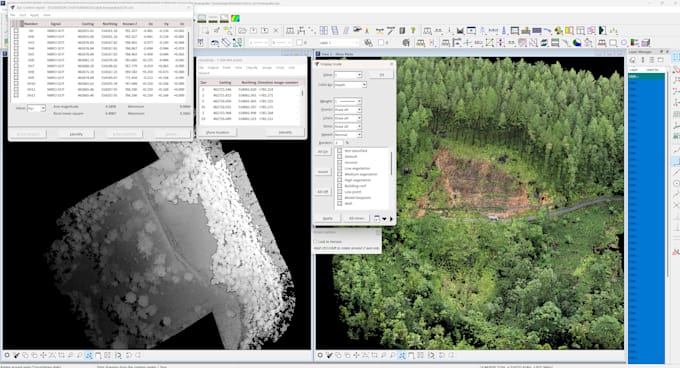
Welcome to my gig! With over 4 years of experience in UAV mapping and 7 years in topographic survey mapping, I offer comprehensive services in geographical information systems (GIS) using high-tech software and top-notch skills.

Services Offered:

  1. Drone Image Processing: From basic tie points to advanced dense point cloud classification, I handle it all.
  2. UAV Drone Mapping: Utilizing Pix4D, Agisoft Metashape Photoscan, TerraSolid and more for accurate mapping.
  3. Lidar / LAS Point Cloud Processing: Expertise in processing lidar data for precise analysis.
  4. 3D Modeling: Creating textured 3D mesh models in OBJ and STL formats.
  5. Digital Elevation Modeling: Generating DEM, DTM, DSM, and TIN for detailed terrain analysis.
  6. Aerial Orthophoto: Producing high-resolution orthophotos for various applications.
  7. Contours: Extracting contour lines for topographic mapping.
  8. Stereo Satellite Processing: Leveraging satellite imagery for stereo analysis.

Software Proficiency:

  • Pix4D
  • TerraSolid
  • DJI Terra
  • Agisoft Metashape Photoscan
  • ArcGIS Pro
  • Global Mapper
  • Erdas Imagine
  • AutoCAD
  • Civil 3D
  • And more!


please feel free to contact me.

Delivery style preference

Please inform the freelancer of any preferences or concerns regarding the use of AI tools in the completion and/or delivery of your order.

Get to know Sandun

Sandun
5.0(2)
  • FromSri Lanka
  • Member sinceMay 2021
  • Last delivery2 months
  • Languages

    Sinhala, English
🌟 Welcome to Geospatial Solutions! 🌍🛰️ Are you in need of expert geospatial services to elevate your projects to new heights? Look no further! I'm Sandun, a dedicated and driven freelancer specializing in web mapping, remote sensing, and spatial analysis. With over 4 years of experience and a Bachelor's degree in Town and Country Planning from the prestigious University of Moratuwa Sri Lanka, I offer a comprehensive suite of geospatial solutions tailored to meet your unique needs.

My Portfolio

Reviews

2 reviews for this Gig
5.0

(2)
(0)
(0)
(0)
(0)
Rating Breakdown
  • Seller communication level
    5
  • Quality of delivery
    5
  • Value of delivery
    5
Sort By
Most relevant
  • I
    image-docs

    ibwand

    DE

    Germany

    5

    Great collaboration! You get exactly what you need, simply and efficiently.

    $50-$100

    Price

    4 days

    Duration

    Helpful?
    Yes
    No
  • I
    image-docs

    ibwand

    DE

    Germany

    5

    Good work, quick responses, a solid understanding of the issues, and the collaboration is enjoyable.

    $50-$100

    Price

    9 days

    Duration

    Helpful?
    Yes
    No

Related tags