Browse categories
Explore
Fiverr Pro
English
$
USD

Level 2
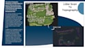
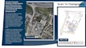
Point Cloud to Topography Services delivers accurate and parametric As-Built Topography Survey Details Including the Building Structures: Commercial, Residents, Sheds, Garages, Barns, Screen Porches, Gazebos, Street Light Poles, Pools, Sign Boards, Manholes, Catch Basin, Driveways, Pavement, Curbs Stone, Gravel Areas, Concrete pads, Patios, Parking Areas, Lawns, Tree lines and any other linear Fences, Walls, Contours.
please contact us before placing the order
Please inform the freelancer of any preferences or concerns regarding the use of AI tools in the completion and/or delivery of your order.
CAD, Revit Drafting and Point Cloud Scan to BIM ,MEP
Level 2
Languages
| (1) | ||
| (0) | ||
| (0) | ||
| (0) | ||
| (0) |
fiveword1

United States
Exactly what I needed - thanks!
$200-$400
Price
2 days
Duration
| (1) | ||
| (0) | ||
| (0) | ||
| (0) | ||
| (0) |
fiveword1
United States
Exactly what I needed - thanks!
$200-$400
Price
2 days
Duration


