Browse categories
Explore
Fiverr Pro
English
$
USD


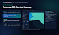
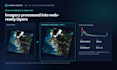
Have GIS data stuck in shapefiles, spreadsheets or desktop GIS? I turn it into a fast, interactive web map or geospatial dashboard your team and clients can use in a browser.
What I build:
Data I work with: Shapefile, GeoJSON, KML, GeoPackage, CSV with coordinates and GeoTIFF, in any common coordinate system.
Why me: I'm a GIS and remote-sensing specialist with 14 years of experience building WebGIS portals, spatial databases and satellite-image workflows, plus an M.Sc. in Data Science. You get clean, documented code, not a locked platform.
Ideal for environmental, engineering, planning, utility, agriculture and real estate teams.
Not included unless agreed: data purchase, heavy data cleaning, imagery acquisition, hosting and paid map APIs.
Send me your data format, layer list and goal, and I'll confirm the right package.
GIS and AI Automation Engineer
Languages
Which data formats can you use?
Shapefile, GeoJSON, KML/KMZ, GeoPackage, CSV with coordinates, GeoTIFF and PostGIS tables. Send a sample and I'll confirm.
What does 'prepared layer' mean?
Data that already has correct geometry and attributes. Fixing broken geometry, merging sources or digitising is a data-cleaning extra.
Do I get the source code?
Yes. All packages include source code and a README. Premium also includes the database schema and GeoServer or API configuration.
Is hosting included?
No. Basic and Standard are easy to host on static hosting. Premium is deployed to your server or cloud; hosting fees are yours.
Do I need a Mapbox or Google key?
Not by default. I use OpenStreetMap-based or other free basemaps with proper attribution. Paid basemaps need your own key.
Can you work with satellite imagery?
Yes. I can add imagery layers or index maps such as NDVI as an extra. Large-area or multi-date analysis is quoted separately.
Can you add to my existing GIS portal?
Yes, if I can access the code and data. Tell me the stack (Leaflet, OpenLayers, GeoServer, ArcGIS JS) first.
What do you need from me?
Your data files or a sample, the coordinate system if known, the list of layers, the interactions you want and hosting details.
Are revisions included?
Yes: 1, 2 or 3 depending on the package, covering the agreed layers and features.
What happens after delivery?
You get a bug-fix window (7, 14 or 30 days). Monthly data refreshes and maintenance are available by custom offer.


