Browse categories
Explore
Fiverr Pro
English
$
USD
SITE DESIGN AND LAYOUT
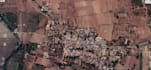
Land Development and Surveying Services using GNSS and Total Station Survey
Description
Offering professional land development and surveying services for parcel creation, layout demarcation, road and junction alignment, contour mapping, existing model creation, and finished model development. Utilizing advanced GNSS and Total Station survey technologies to ensure accuracy and precision.
Services
- *Parcel Creation*: Create precise parcel boundaries and layouts for real estate development, subdivision, and land consolidation projects
- *Layout Demarcation*: Demarcate and stake out layouts for construction projects, including building footprints, roads, and utilities
- *Road and Junction Alignment*: Design and align roads and junctions for optimal traffic flow and safety
- *Contour Mapping*: Generate accurate contour maps for land planning, grading, and drainage design
- *Existing Model Creation*: Develop detailed existing models of sites, including topography, features, and infrastructure
- *Finished Model Development*: Create finished models of developed sites, incorporating design and construction data
- *GNSS and Total Station Survey*: Conduct surveys using GNSS