Browse categories
Explore
Fiverr Pro
English
$
USD


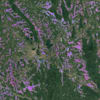
we will provide you research based mapping services with remote sensing
we are capable of processing satellite images and providing you with a vast range of application-ready products.
. agriculture lands mapping
. vegetation/crop types mapping
. vegetation health monitoring
. Agricultural drought monitoring
. Yield Estimation
. cultivated paddy/crop lands mapping
.crop phenological parameter extraction and mapping
Forest area mapping
Forest cover types mapping
Forest fire detection
Forest fire hazard monitoring
Detecting forest trees' health
Drought monitoring
Forest trees diseases and insects infestation
Assessment of wind damage and other severe climatic conditions
Detecting deforestation and forest degradation
Logging activities monitoring
deforestation and afforestation monitoring
Forest Biomass estimation
Tree height estimation.
Forest trees water stress detection.
forest 3D modelling
urban aplications
atnospheric mapping
any other Remote Sensing GIS tasks
works with satellites embeddings data.
We are capable of map the details your area and more by using optical and SAR, Thermal and LIDAR remote sensing data
Order now!
Thanks
Nayanika
Remote Sensing GIS Expert
Languages
| (2) | ||
| (0) | ||
| (0) | ||
| (0) | ||
| (0) |
baonguyen940

Australia
absolutely outstanding. great work comes with reasonable price. professional!
$100-$200
Price
8 days
Duration
Seller's Response
iherreraval

Chile
Great work, delivered as promised and on time.
Up to $50
Price
8 days
Duration
Seller's Response
| (2) | ||
| (0) | ||
| (0) | ||
| (0) | ||
| (0) |
baonguyen940
Australia
absolutely outstanding. great work comes with reasonable price. professional!
$100-$200
Price
8 days
Duration
Seller's Response
iherreraval
Chile
Great work, delivered as promised and on time.
Up to $50
Price
8 days
Duration
Seller's Response


