Browse categories
Explore
Fiverr Pro
English
$
USD

Level 1
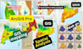
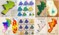
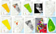
I am a GIS specialist with 6 years of experience in spatial analysis, remote sensing, and professional GIS mapping & cartography.
I deliver solutions using QGIS, ArcGIS Pro, Google Earth Engine, Python, R, ENVI, and WebGIS. My expertise includes spatial analysis, remote sensing, and high-quality cartographic visualizations for research or any GIS & RS-related project.
Lets start collaboration.
Best regards,
Smith
Level 1
Languages
1. What is GIS and how can it benefit my project?
GIS is used to map, analyze, and visualize spatial data. It helps uncover geographic patterns, supports data-driven decision-making, and enhances the understanding of your project's spatial components.
2. What GIS and Remote Sensing services do you provide?
I offer a wide range of services, including GIS mapping, spatial analysis, remote sensing, WebGIS development, 3D terrain modelling, satellite image processing, geospatial data management, and custom scripts using ArcGIS, QGIS, and Python.
3. How do you ensure the accuracy of your results?
I use reliable data sources and apply validation methods like accuracy assessment, ground-truthing, and quality control checks. With over 10 years of experience, I deliver precise and reliable spatial analysis results.
4. Can you use specific GIS software or tools for my project?
Yes. I'm proficient in ArcGIS Pro, QGIS, Google Earth Engine, ENVI, Python, SNAP, and R. I can work with the tools you prefer or recommend the most suitable one for your project.
5. What details do you need to start my project?
I’ll need your area of interest, project objectives, available data (if any), preferred outputs, and any technical or visual preferences. This helps me deliver tailored, effective solutions.
6. How long does a typical project take?
Timelines vary based on project complexity, data volume, and required outputs. Once I review your project brief, I’ll provide a realistic and clear delivery estimate.
7. Do you offer cloud-based GIS solutions?
Yes, I can integrate GIS workflows into cloud platforms like Google Earth Engine, AWS, or Azure, enabling scalable, efficient, and collaborative geospatial solutions.
8. How is my data handled and kept secure?
All data is treated with full confidentiality. I use secure data storage and processing methods, ensuring your project information is protected at every step.
9. What is the pricing structure for your services?
Pricing depends on project complexity, tools used, and turnaround time. Please share your project details for a custom quote based on your exact needs.
10. How can I get in touch to discuss my project?
You can message me directly here on Fiverr. I'm quick to respond and happy to answer any questions before starting your order.


