Browse categories
Explore
Fiverr Pro
English
$
USD


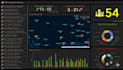
Are you looking for a powerful, interactive web GIS application to visualize, analyze, or manage spatial data?
With my expertise in GIS, Remote Sensing, and Full-Stack Web Development, I will design and develop a custom GIS web app tailored to your exact requirements from environmental monitoring to real-time tracking and land management systems.
What Youll Get:
Use Cases:
I ensure clean, professional UI, smooth performance, and fully functional code ready for deployment.
Contact me before placing an order so we can discuss your pro
Specialist in GIS, Remote Sensing Mapping, YouTube video Editor
Languages
What technologies do you use for Web GIS apps?
I use Leaflet.js, Mapbox GL JS, Google Maps API, or ArcGIS JS API for mapping, combined with React, Node.js, and Firebase/MongoDB for full-stack functionality.
Can you integrate my shapefile or satellite data?
I can integrate your Shapefile, GeoJSON, KML, or raster layers and visualize them interactively on the web map.
Can you customize the UI or brand theme?
Absolutely I can match your branding colors, logo, and layout preferences for a professional look.
